| Imagefile |
Soundfile |
Cahto |
POS |
English |
Semanticfield |
|
|
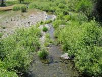
Ban'tcnoondilyeegh |
n a |
Ban'tcnoondilyeegh, "Where Houseflies Settle Under" ("just northwest of Laytonville and but a short distance from the place now occupied by the Indians near Laytonville.") |
pln
|
© 2004 Sally Anderson |
|
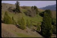
Ban'tcteenoondilkot |
n a |
Ban'tcteenoondilkot, "Houseflies Settle on the Water Creek" ("on the north bank of the northern branch of the head of the south fork of Eel river at a point about a mile south-southwest of Cahto.") |
pln
|
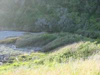
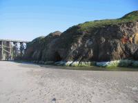
| Link to images at www.californiacoastline.org |
|
Baanchowseekw'it |
n a |
Baanchowseekw'it, "Mussel Rock On It" |
pln
|
|
|
Beeniichii' |
n a |
Beeniichii' |
pln
|
|
|
Beeshootcinmii' |
n a |
Beeshootcinmii' |
pln
|
|
|
Bink'aabii' |
n a |
Bink'aabii', "Lake Valley" |
pln
|
|
|
Bink'itchow-lhgishding |
n a |
Bink'itchow-lhgishding, "Big Forked Lake Place" |
pln
|
|
|
Bin'milgohkot |
n a |
Bin'milgohkot, "Fish Spearing Shelter Creek", near Clark Ranch |
pln
|
|
|
Chilhsaitcding |
n a |
Chilhsaitcding. "Little Dry Tree Place" |
pln
|
|
|
Chinch'idjoosbii' |
n a |
Chinch'idjoosbii', "Hollow Tree Valley" |
pln
|
|
|
Chinkii'nooldeelai' ? |
n a |
Chinkii'nooldeelai' ? |
pln
|
|
|
Chinlhgaichowding |
n a |
Chinlhgaichowding, "Big White Tree Place" |
pln
|
|
|
Chins'aanding |
n a |
Chins'aanding, "Tree Lies Place" (near Laytonville Cemetery) |
pln
|
© 2004 Sally Anderson |
|
Chins'aanding |
n a |
Chins'aanding, "Tree Lies Place," Abalone Pt. (just north of DeHaven) |
pln
|
|
|
Chinshing |
n a |
Chinshing, Sherwood Pomo |
pln
|
| Link to 1906 photo by P.E. Goddard at Online Archive of California |
|
Ching Waanintc'iiding |
n a |
Ching Waanintc'iiding, Bald Hill, "Wind Tree Place" (also called Ching-ch'ilhwohding) |
pln
|
| Link to 1906 photo by P.E. Goddard at Online Archive of California |
|
Ching-ch'ilhwohding |
n a |
Ching-ch'ilhwohding, Bald Hill (also called Ching Waanintc'iiding) |
pln
|
|
|
Ching-kinaaghibaasding |
n a |
Ching-kinaaghibaasding, "Several Sticks Turning Round and Round Place" |
pln
|
|
|
Ching-lhgishding |
n a |
Ching-lhgishding, "Forked Tree Place" |
pln
|
|
|
Ching-tc'eelaa'bii' |
n a |
Ching-tc'eelaa'bii', "Sticks Come Out? Place" |
pln
|
|
|
Ch'ghashdiniiding |
n a |
Ch'ghashdiniiding, "Making a Noise Place" |
pln
|
© 2004 Sally Anderson |
|
Ch'ghaats'ee'-kwonteelhbii' |
n a |
Ch'ghaats'ee'-kwonteelhbii', Round Valley, "Dogbane Valley" |
pln
|
© 2004 Sally Anderson |
|
Ch'ishleeh |
n a |
Ch'ishleeh, the fish are running in already (place name ???) |
pln
|
|
|
Ch'leeh |
n a |
Ch'leeh, "Fish Run" |
pln
|
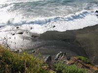
| Link to images at www.californiacoastline.org |
|
Ch'leehkot |
n a |
Ch'leehkot, Chadburn Gulch ("fish come in there river") |
pln
|
© 2004 Sally Anderson |
|
Ch'lhaanding |
n a |
Ch'lhaanding, "Fighting Place," Hardy Creek Village |
pln
|
|
 |
Ch'ninkat |
n? |
Ch'ninkat, "Deer Lick," a spring north of Ch'ninkaabii' |
pln
|
© 2004 Sally Anderson |
|
Ch'ninkatchii' |
n a |
Ch'ninkatchii', "Deer Lick Creek Mouth" [somethings come-in it] |
pln
|
© 2004 Sally Anderson |
|
Ch'ninkatchii'-kiiyaahaang |
n a |
Ch'ninkatchii'-kiiyaahaang, "Deer Lick Creek Mouth Tribe" |
hupln
|
|
|
Ch'ninkaabii' |
n a |
Ch'ninkaabii', "Deer Lick Valley" |
pln
|
|
|
Ch'ninkaahlai' |
n a |
Ch'ninkaahlai', "Deer Lick Peak" |
pln
|
|
|
Ch'ninkaahlai'-kiiyaahaang |
n a |
Ch'ninkaahlai'-kiiyaahaang, "Deer Lick Peak Tribe" |
hupln
|
|
|
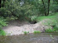
Daa'lhgailai' |
n a |
Daa'lhgailai', "Dogwood Peak" |
pln
|
|
|
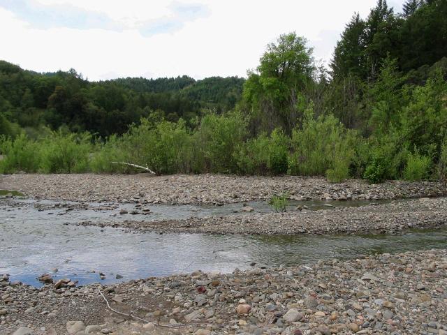
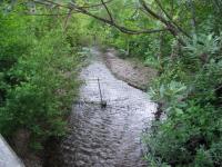
Daahtl'ool'kwot |
n a |
Daahtl'ool'kwot, "Grape Creek," Rattlesnake Creek [at northern end of Cahto territory] |
pln
|
|
|
Diltciik-nilhtcin-ding |
n a |
Diltciik-nilhtcinding, "Yellow Pine Grows Place" |
pln
|
|
|
Diltciik-nilhtcing-kwot |
n a |
Diltciik-nilhtcinkwot, "Yellow Pine Grows Creek" |
pln
|

© 2004 Sally Anderson |
|
Diltciik-ninsing-kwot |
n a |
Diltciik-ninsingkwot, "Yellow Pine Hillside Creek," Wilson Creek |
pln
|
© 2004 Sally Anderson |
|
Dindai-ntcee'tc-ding |
n a |
Dindai-ntcee'tc-ding, "Little Bad Flint Place" |
pln
|
|
|
Dist'eeghitc-uuyeeh |
n a |
Dist'eeghitc-uuyeeh, "Under the Crooked Madrone," on the western side of Long valley at a point about two miles south-southeast of Laytonville. |
pln
|
|
|
Diineeschowkwot |
n a |
Diineeschowkwot, "Big Willow Creek," Dutch Henry Creek |
pln
|
| Link to images at www.californiacoastline.org |
|
Diinees-s'aanding |
n a |
Diinees-s'aanding, "Willow Lies Place," Westport |
pln
|
|
|
Gaashchow-tciik-bii' |
n a |
Gaashchow-tciik-bii', "Red Redwood Valley," Jackson Valley |
pln
|
|
|
Gaashkwot |
n a |
Gaashkwot, "Yew Creek", Bennett Creek tributary |
pln
|
|
|
Gaashtckwot |
n a |
Gaashtckwot, "Little Yew Creek" |
pln
|
|
|
Gaashtc'eeng'aading |
n a |
Gaashtc'eeng'aading, "Yew Sticks Out Place" |
pln
|
|
|
Gaashtc'eeng'aading-kiiyaahaang |
n a |
Gaashtc'eeng'aading-kiiyaahaang, "Yew Sticks Out Place Tribe" |
hupln
|
© 2004 Sally Anderson |
|
Iintc'ee'nchaahding |
n a |
Iintc'ee'nchaahding, Cleone, "Big Deer Place" |
pln
|
|
|
Kai-kwontaah |
n a |
Kai-kwontaah, Cahto rancheria, "Winter Village" |
pln
|
|
|
Kaach'aang'chowk'it |
n a |
Kaach'aang'chowk'it, "Big Hole in the Ground Peak" |
pln
|

© 2004 Sally Anderson |
|
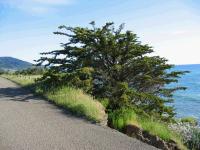
Kaatineebii' |
n a |
Kaatineebii', "Road Going Up Valley," Rockport town, Cottaneva |
pln
|
| Link to images at www.californiacoastline.org |
|
Kaatineebii' Tc'eeghiliinding |
n a |
Kaatineebii' Tc'eeghiliinding, Cottaneva beach area, "Road Going Up Valley - Place Where the Water Flows Out," Cottaneva Creek mouth |
pln
|
© 2004 Sally Anderson |
|
Kaatiniibii' |
n a |
Kaatineebii', "Road Going Up Valley," Rockport town, Cottaneva |
pln
|
|
|
Keetc'ing-kiiyaahaang |
n a |
Keetc'ing-kiiyaahaang, Southern Sinkyone tribe |
hupln
|
© 2004 Sally Anderson |
|
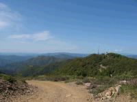
Kiik |
n a |
Kiik, Branscomb Mountain (= Cahto Peak) ("children") |
pln
|
|
|
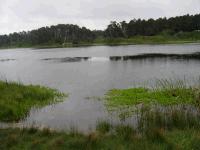
Kolk'oschowbii' |
n a |
Kolk'oschowbii', "Big Tule Valley," Little Lake, Willits |
pln
|
|
|
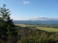
Konteelhbii' |
n a |
Konteelhbii', "The Valley," Long Valley |
pln
|

© 2004 Sally Anderson |
|
Konteelhchowbii' |
n a |
Konteelhchowbii', "The Big Valley," Round Valley |
pln
|
|
|
Konteelhneesbii' |
n a |
Konteelhneesbii', "The Long Valley," Long Valley |
pln
|

© 2004 Sally Anderson |
|
Konteelhtcbii' |
n a |
Konteelhtcbii', "Little Valley" (the valley just north of Long Valley on Ten Mile Creek) |
pln
|

© 2004 Sally Anderson |
|
Konteelhtc-kiiyaahaang |
n a |
Konteelhtc-kiiyaahaang, "Little Valley Tribe" (the band in Konteelhtcbii', just north of Long Valley) |
hupln
|
|
|
Koshbii' |
n a |
Koshbii', "Blackberry Valley" |
pln
|
|
|
Koshbii'-kiiyaahaang |
n a |
Koshbii'-kiiyaahaang, "Blackberry Valley Tribe" (band in Koshbii' area) |
hupln
|
|
|
Koshkaatinii |
n a |
Koshkaatinii, "Blackberry Trail Up," Blocksburg |
pln
|
|
|
Koolhkal'-uu'aang'lai' |
n a |
Koolhkal'-uu'aang'lai', "Flea's Nest Peak" |
pln
|
|
|
K'ai'bii' |
n a |
K'ai'bii', "Hazel Valley" |
pln
|
© 2004 Sally Anderson |
|
K'ai'kwot |
n a |
K'ai'kwot, "Hazelnut Creek", near Peterson Creek |
pln
|
© 2004 Sally Anderson |
|
K'ai'tc-chii' |
n a |
K'ai'tc-chii', "Little Hazel Creek Mouth", near Peterson Creek |
pln
|
© 2004 Sally Anderson |
|
K'aa'chowkwot |
n a |
K'aa'chowkwot, "Big Arrow Creek", near Wilson Creek |
pln
|
|
|
K'aa'taaskaal'ding |
n a |
K'aa'taaskaal'ding, "Broken Arrow Place" |
pln
|
|
|
K'ishbii' |
n a |
K'ishbii', "Alder Valley" |
pln
|
© 2004 Sally Anderson |
|
K'ishtaahchii' |
n a |
K'ishtaahchii', "Alder Creek Mouth", near Peterson Creek |
pln
|
© 2004 Sally Anderson |
|
K'ishtaahkwot |
n a |
K'ishtaahkwot, "Among the Alders Creek", near Peterson Creek |
pln
|
|
|
K'ishtaakashbii' |
n a |
K'ishtaakashbii', "Alder Fell in Water Valley" |
pln
|
|
|
K'ish-uuyeeh-too-kwot |
n a |
K'ish-uuyeeh-too-kwot, "Under the Alder Water Creek", Clark Ranch area |
pln
|
|
|
K'iing'naanit |
n a |
K'iing'naanit, "Serviceberry ??" |
pln
|
|
|
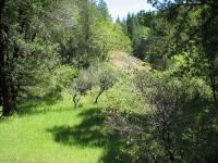
Ltaaghtaahding |
n a |
Ltaaghtaahding, on Big Rock Creek, "Among the Black Oaks Place" |
pln
|
|
|
Lheedoon'tc-lai' |
n a |
Lheedoon'tc-lai', "Little Salt Peak" |
pln
|
© 2004 Sally Anderson |
|
Lheetcghaa'chinee'ding |
n a |
Lheetcghaa'chinee'ding, near Peterson Creek, "Ground Moss Base Place" |
pln
|
|
|
Lheetcghaa'too'chii' |
n a |
Lheetcghaa'too'chii', "Ground Moss Water Creek Mouth" |
pln
|
© 2004 Sally Anderson |
|
Lhit'anchii' |
n a |
Lhit'anchii', "Smoke Side Creek Mouth", Lewis Creek area |
pln
|
© 2004 Sally Anderson |
|
Lhit'ankwot |
n a |
Lhit'ankwot, "Smoke Side Creek", Lewis Creek |
pln
|

© 2004 Sally Anderson |
|
Lhoo'yaash Ch'isleegh |
n a |
Lhoo'yaash Ch'isleegh, "Surf Fish Run," Juan Creek |
pln
|
|
|
Lhtc'iishtc'eetinding |
n a |
Lhtc'iishtc'eetinding, "Dust Comes Out Place," Sherwood Valley |
pln
|
|
|
Lhtc'iishtc'eetinding-kiiyaahaang |
n a |
Lhtc'iishtc'eetinding-kiiyaahaang, "Dust Comes Out Place Tribe," Sherwood Valley Tribe, Sherwood Pomo |
pln
|
|
|
Naadeel'naadaa'ding |
n a |
Naadeel'naadaa'ding, "Sugar Pine ?? Place" |
pln
|
© 2004 Sally Anderson |
|
Naakee'itckwot |
n a |
Naakee'itckwot, "Duck Creek," Pudding Creek ? |
pln
|
|
|
Naakong-konteelbii' |
n a |
Naakong-konteelbii', "Clover Valley" (other name for Sherwood Valley) |
pln
|
|
|
Naaniitckwot |
n a |
Naaniitckwot, "Duck Creek," Howard Creek |
pln
|
Walter Knight © California Academy of Sciences, by permission |
|
Naasliingchii' |
n a |
Naasliingchii', "Flows Around Creek Mouth," Garberville, South Fork of Eel River |
pln
|
|
|
Nee'-booshee'-kw'it |
n a |
Nee'-booshee'-kw'it, "Humped Up Ground Hill" |
pln
|
|
|
Nee'kaisboot' |
n a |
Nee'kaisboot', "Ground Raised Up" (place name) |
pln
|
| Link to images at www.californiacoastline.org |
|
Nee'lhgishding |
n a |
Nee'lhgishding, "Land Gap," Low Gap |
pln
|
|
|
Nee'lhitchowbii' |
n a |
Nee'lhitchowbii', "Big Earth Smoke Valley" |
pln
|
|
|
Nee'lhsowchii' |
n a |
Nee'lhsowchii', "Blue Earth Creek Mouth" |
pln
|
|
|
Nee'lhsowchii'-kiiyaahaang |
n a |
Nee'lhsowchii'-kiiyaahaang, "Blue Earth Creek Mouth Tribe" |
hupln
|
|
|
Nee'lhsowkwot |
n a |
Nee'lhsowkwot, "Blue Earth Creek," Blue Hill Creek |
pln
|
|
|
Nee'lhsowkwot-kiiyaahaang |
n a |
Nee'lhsowkwot-kiiyaahaang, "Blue Earth Creek Tribe," Blue Hill Creek tribe |
hupln
|
|
|
Nee'lhtciikbii' |
n a |
Nee'lhtciikbii', "Red Earth Valley," Red Mountain (perhaps valley near it?) |
pln
|
|
|
Nee'lhtciikchinee'ding |
n a |
Nee'lhtciikchinee'ding, "Red Earth Base Place" |
pln
|
|
|
Nee'lhtciikchowtis |
n a |
Nee'lhtciikchowtis, "Above the Big Red Earth" |
pln
|